Israel expands Gaza control zone
Ceasefire yellow line shifts west as new forts and berms appear, UN says shelters end up inside unmarked fire zones
Images
 A yellow block demarcating the yellow line in Khan Younis in January. Photograph: Abdel Kareem Hana/AP
theguardian.com
A yellow block demarcating the yellow line in Khan Younis in January. Photograph: Abdel Kareem Hana/AP
theguardian.com
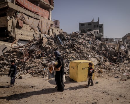 People in Gaza City set out for areas they consider safer after the Israeli army moved the yellow line in November. Photograph: Anadolu/Getty Images
theguardian.com
People in Gaza City set out for areas they consider safer after the Israeli army moved the yellow line in November. Photograph: Anadolu/Getty Images
theguardian.com
Israeli forces have shifted Gaza’s ceasefire boundary westward in multiple places since October, according to reporting by The Guardian and analysis by Forensic Architecture. Residents in neighbourhoods such as al‑Tuffah in Gaza City say they have woken to find the “yellow line” — the demarcation agreed under a US-brokered truce — moved overnight, placing homes and makeshift shelters inside a zone where the army treats any person or vehicle as a target.
The yellow line was meant to be temporary, pending further Israeli withdrawals after the first phase of the October ceasefire. That phase has stalled amid disputes over Hamas disarmament and continued Israeli strikes. The practical result, aid groups say, is that the boundary has become less a line than a moving system: a marked demarcation backed by earthworks, fortified positions, and an adjacent “orange line” buffer that exists only on maps and can shift without warning.
The Guardian reports that Israel’s controlled area expanded beyond the 53% of Gaza implied in the original ceasefire maps; Forensic Architecture estimated Israel held 58% by December and has continued edging forward. In some locations, yellow concrete blocks used as markers were moved in December and January as the army advanced, particularly in urban areas. One resident, Faiq al‑Sakani, said the line moved roughly 100 metres in January toward the Salah al‑Din road, Gaza’s main north–south artery, and that people sheltering near the road were fired upon during the advance.
Along the shifting boundary, the military has been building what looks less like a temporary cordon than an infrastructure project. Haaretz, cited by The Guardian, reports more than 10 miles of earth berms have been erected, giving tanks and snipers direct lines of sight over large sections of destroyed neighbourhoods. The Guardian says seven new concrete forts have been built in recent months, bringing the total across Gaza to 32, with new construction concentrated along the yellow line.
Aid organisations describe a coordination regime that follows the moving geography. They say Israeli liaison officers refer to an “orange line” 200–500 metres from the yellow line; crossing it requires prior coordination. But because the orange line is not physically marked, the burden of compliance falls on civilians and aid workers trying to infer where lethal rules begin. The UN reported in March that it had been told the orange line had moved forward, placing 10 UN facilities — including emergency shelters — on the wrong side.
The accumulating fortifications and shifting boundaries matter because they change the economics of return. A ceasefire line that moves at night and is enforced as a free-fire zone makes rebuilding and resettlement a gamble. It also creates a steady pressure for displacement without the formal announcement of annexation: families relocate because the boundary has relocated to them.
In Khan Younis and Gaza City, the markers are concrete blocks and fresh berms. For residents, the signal is simpler: the map they were told would hold still has started moving again.